Why blue carbon science is rewriting the rules of the game: the key questions for the next decade
The core point today is that “blue carbon” is not primarily biomass. It is primarily carbon stored in the sediments of mangroves, salt marshes, and seagrass meadows, so methodologies are shifting their center of gravity toward soil/sediment carbon and non-CO₂ gases such as CH₄ and N₂O. This changes emission factors, raises the bar on uncertainty, and makes it harder to “issue credits” based on generic assumptions. Source: USGS.
The benchmark that matters to CFOs and procurement teams is that the average long-term accumulation rates often reported in the literature are about 5.1–8.3 tCO₂e/ha/year, with high variability by habitat and conditions. This is not suitable for project accounting, but it is useful for spotting overly aggressive commercial claims—especially when people talk about “rapid restoration” or areas with complex coastal dynamics. Source: Project Drawdown.
Pressure for stricter rules is growing because the market is asking for less discretion. The direction is twofold: methodology revision and digitization of the rules, with methodologies becoming more “computable” and less dependent on PDFs interpreted differently from project to project. This is practical for B2B buyers and insurers because it makes audits and assurance more verifiable. An example of this trajectory: digital transformation initiatives linked to methodologies such as VM0033.
The claims context changes visibly in 2026. Claims codes and the focus on “high-integrity credits” push toward credits with stricter criteria and with recognizable labels or requirements, in a landscape that also echoes discussions around CCP and Article 6.4 as policy and integrity reference points. Source: VCMI Claims Code of Practice v3.0 (April 2025).
Scale and governance are no longer “nice-to-haves.” Large mangrove projects with revenue-sharing mechanisms and targets for first issuances or credits by end-2026 show how science, local rights, and markets intersect. For buyers, it is a reminder: quality is not only MRV—it is also operational continuity and social license. Source: Mongabay.
Simplifying methodologies: which steps can be standardized and which cannot (baseline, additionality, leakage, permanence)
Baseline is the first area where a lot can be standardized—but not everything. The parts that depend on repeatable data can be made more rules-based, such as geospatial datasets, habitat classifications, and anthropogenic pressure scenarios. The portion that depends on sedimentary dynamics, hydrology, and salinity inevitably remains site-specific, because these are direct drivers of carbon accumulation and release. This is where the trend toward a digitized methodology matters: less room for interpretation, more controls on inputs and formulas.
Additionality in 2026 tends to become more “document-based” and less narrative. Rules are moving toward stronger evidence on financial and regulatory barriers and on common practice. For a buyer, this translates into a simple checklist to request during due diligence: realistic CAPEX and OPEX, permits and constraints, business-as-usual alternatives, and why without carbon revenue the project would not proceed or would proceed at a reduced scale. The push toward more rigorous, Paris-aligned frameworks in programs points in the same direction.
Leakage is not a detail, because along coasts pressures can shift easily. You need to distinguish activity leakage—i.e., displacement of aquaculture, fishing, or conversion to nearby areas—from “ecological” leakage, such as sediment export or the displacement of disturbances. Some mitigations can be standardized, for example buffers and landscape-scale management plans. Parameters remain local, however, because they depend on coastal economics, enforcement, and geomorphology.
Permanence in blue carbon is a mix of risks that cannot be solved with a single measure. Physical risk such as storm surge and erosion matters, as does anthropogenic risk such as land-use change, and institutional risk such as enforcement capacity. That is why market tools such as buffer pools, reserves, and—where available—insurance become central as an additional layer of mitigation. Source: WWF, state of the oceans and seas (2024).
The “conservation vs restoration” distinction is becoming more important. Some methodologies are evolving to include conservation as well, and therefore credits from avoided losses—not only restoration. The trade-off is greater complexity around baseline and leakage, because you must demonstrate what would have happened without the intervention and where pressures would shift. For Italian developers working in protected areas or in contexts such as Natura 2000 (an EU network of protected sites that also applies in Italy), this is practical: conservation can make sense, but it requires a more robust evidence package.
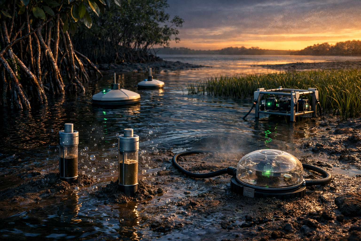
MRV in coastal environments: how to combine remote sensing, sampling, and models to reduce costs and uncertainty
MRV that holds up in 2026 is almost always hybrid. The typical structure—often described as digital MRV (dMRV) and Tier 2–Tier 3 approaches—combines three layers: (1) remote sensing for activities, areas, and changes, (2) in situ campaigns for sediment carbon stocks, (3) models for interpolation and scenarios. The benefit is lower cost per hectare and more frequent control. The cost is that you need serious QA/QC, otherwise you only automate errors.
Remote sensing is powerful for change detection, but it has clear limits. Satellites typically operate at 5–30 m resolution, excellent for screening and land-cover variation. For submerged meadows, however, more advanced approaches are often needed, such as water-column corrections, bathymetry, and multi-temporal analysis. Source: review on remote sensing of coastal habitats.
LiDAR and multispectral data help when the question is “how scalable is MRV.” There are examples of seagrass mapping across about 1,100 km² using LiDAR and imagery, useful for showing that scale is possible—but it requires budget and data design. Source: same line of literature on ScienceDirect.
Algorithms and cloud platforms reduce time, not accountability. Cloud-native workflows, for example on Google Earth Engine, enable multi-habitat classifications by integrating signals such as tide level, phenological features, and SAR to improve accuracy and reduce “false changes” driven by tides. This is
Data and emission factors should be anchored to solid datasets where possible. Using global or consortium libraries—for example datasets with 16,143 multi-country soil profiles—can reduce uncertainty and make the choice between defaults and site-specific measurements more defensible. In due diligence, the right question is not “did you measure everything?”, but “where do you use defaults and why is that conservative?”. Source: Smithsonian Environmental Research Center, Coastal Carbon Data.
Audit automation becomes realistic only if the methodology is digitized. When rules, formulas, versioning, and data checks are part of the methodology, errors and cherry-picking are reduced. This is exactly the kind of thing procurement and assurance care about: fewer debates about interpretation, more verification of data traceability.
Blue carbon-specific risks that complicate crediting: extreme events, erosion, land-use change, and local governance
Extreme events are a project risk, not just an abstract climate risk. Storms and hurricanes can cause mangrove mortality, erosion, and the mobilization of carbon in sediments. For a buyer, this translates into concrete requirements: a risk register, stress tests on frequency and intensity, and an MRV plan that can detect area loss and damage on timelines compatible with crediting.
Erosion and coastal dynamics make the baseline a moving variable. The land–sea boundary shifts, and area loss can invalidate assumptions made at the start. This requires more frequent MRV and, often, geomorphological models. This is particularly relevant in contexts such as the Adriatic Sea, river deltas, and lagoons (including in Italy), where morphology also changes due to human interventions.
Land-use change often matters more than biology. Aquaculture, port development, and coastal tourism can rapidly change incentives and pressures. Regulatory risks also weigh heavily: public coastal concessions, landscape constraints, and permitting processes determine additionality and leakage at least as much as ecological parameters.
Local governance is a leading indicator of permanence. Revenue-sharing structures and community rights—including revenue split percentages reported in mangrove project case studies—are a useful proxy for social risk and operational continuity. If the community does not see clear benefits, the risk of conflict and loss of territorial control increases. Source: Mongabay.
Risk transfer tools are entering the “permanence strategy.” Parametric insurance approaches applied to mangrove contexts, with hazard-based triggers and rapid payouts, can make a project more bankable and reversal management more credible. Source: Reinsurance News on a parametric partnership for mangrove protection.
Impacts on the voluntary market: credit quality, prices, insurance, and what to ask in due diligence before buying
Quality becomes a procurement requirement, not a preference. On the buyer side, demand is growing for high integrity credits and, where applicable, for credits with labels consistent with schemes such as CCP or equivalents. In parallel, claims codes narrow the options after 1 January 2026, so buyers need to plan supply and contracts in advance—not at year-end. Source: VCMI Claims Code of Practice v3.0.
Paris alignment in programs affects the pipeline. Some standards are imposing scheduling and retirement of non-aligned methodologies, and require Paris-aligned versions for 2026 vintages. This increases lead time and can raise VVB costs, because verification becomes more demanding and more data-driven. Source: Gold Standard, activity requirements for blue carbon and freshwater wetlands.
Insurance and forms of credit enhancement are becoming more common because they cover different risks. Carbon insurance, parametric cover, and delivery guarantees reduce non-issuance risk, reversal risk, and challenge risk. One market example is insurance for an investment in a registered mangrove project, designed to support the delivery of high-quality credits to the market. Source: OxCarbon press release.
Technical due diligence must be repeatable and documentable. The five key questions to always ask about the PDD and MRV plan are: (1) methodology version and why choices are conservative, (2) disaggregation of pools—biomass vs sediment, (3) handling of CH₄ and N₂O, (4) MRV frequency and quality controls, (5) extreme-event risk management plan and how it is reflected in the buffer pool. For orientation, Verra’s page on blue carbon focus areas is also useful.
Operational due diligence is what protects against reputational risk. Chain of title, concessions and rights, governance and benefit sharing, enforcement capacity, and a digital audit trail matter as much as sediment cores. Digitization, if done well, helps because registries and data lineage make it easier to show who did what, when, and with which data.
Practical roadmap for Italian developers and corporate buyers: how to prepare for new methodologies and stricter claims (CSRD, SBTi, ICVCM)
For developers in Italy, the operational sequence is more
Preparing for the “digital method” is a toolchain and data-governance choice. Assessing dMRV means defining versioning, controls, and accountability for datasets and calculations, to reduce reporting and audit time. The trend toward digitized methodologies, also cited in the context of VM0033, goes exactly in this direction.
Buyers need an updated internal playbook, not just a list of “nice” projects. The policy on credit use for Scope 3 and claims should include minimum requirements: preference for credits with an integrity label or equivalent criteria, contracts with replacement clauses, disclosure of reversal risk, and insurance where available. The VCMI Claims Code is a practical reference for understanding what becomes harder after 1/1/2026.
CSRD and ESRS push toward traceability and verifiability, even if the scope is evolving. Proposals and amending acts aim at simplifications, but the direction remains: assurance, comparability, and clear documentation. For credit buyers, this means clearly explaining the role of credits relative to reductions, and demonstrating quality and due diligence with evidence. Source: European Parliament briefing.
The 2026 timeline should be treated as a supply-chain constraint. Three operational deadlines matter: (a) tightening of claims after 1/1/2026 in some frameworks, (b) Paris-aligned requirements for 2026 vintages in some standards, (c) procurement that must lock in supply 12–24 months earlier if it wants to avoid shortages of premium credits. Source: VCMI Claims Code v3.0.
Box: final checklist for procurement and the investment committee (questions to ask)
- Methodology and version: what is it, and what changes compared to the previous version
- Datasets and emission factors: defaults vs site-specific measurements, and why the choice is conservative
- Non-CO₂ management: how CH₄ and N₂O enter the calculation and uncertainty
- Buffer and reversals: rules, stress tests, and what happens in the event of an extreme event
- Local governance: rights, benefit sharing, enforcement, grievance mechanisms
- Digital audit trail: data traceability, versioning, automated checks
- Insurance: is there parametric cover or carbon insurance, and what does it actually cover Soil data source and due diligence support: SERC Coastal Carbon Data.